1. Base Station Setup Tips:
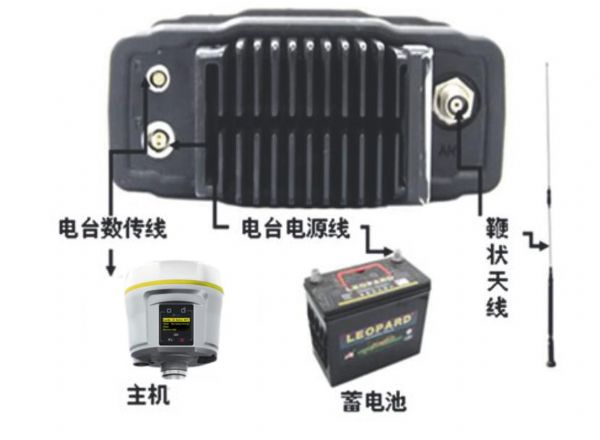
When setting up an RTK base station, it's important to choose a high and open location with no nearby high-voltage lines within 100 meters. Avoid placing the base station near communication towers or sources of interference like radio transmitters. This helps ensure stable signal reception and transmission.
The base station host should be placed at least 3 meters away from the top of the radio antenna to prevent signal interference. Make sure all cable connections are secure and properly ordered. Connect the battery last, ensuring that red is connected to the positive terminal and black to the negative. Always disconnect the power first when finishing work to avoid damage.
If working in rainy or sunny conditions, cover the battery and radio with a soft bag or similar item to protect them from weather damage and extend their lifespan.

Figure 1: Connection diagram
2. Handheld Device Connection Tips
After successfully starting the base station via Bluetooth, exit the geodetic software or manually change the port configuration before disconnecting the Bluetooth connection. Remove the COM port from Bluetooth settings to prevent unexpected disconnections that could stop differential data transmission. Note: Many modern RTK systems now use Wi-Fi hotspots instead of Bluetooth, which can reduce connection issues (e.g., the Chinese i80 model).
Monitor the battery voltage displayed on the radio panel. If the maximum output voltage drops below 11 volts, the radio may not transmit properly. If it’s below 12 volts, switch to low power mode (under 10 watts) to avoid malfunctions.
Once the base station GPS receiver is set up correctly, avoid moving it. If it accidentally shifts, you may need to reset local coordinates if using an unknown point, or re-center and re-measure the slant height if using a known point. Then restart the base station with the handheld device.

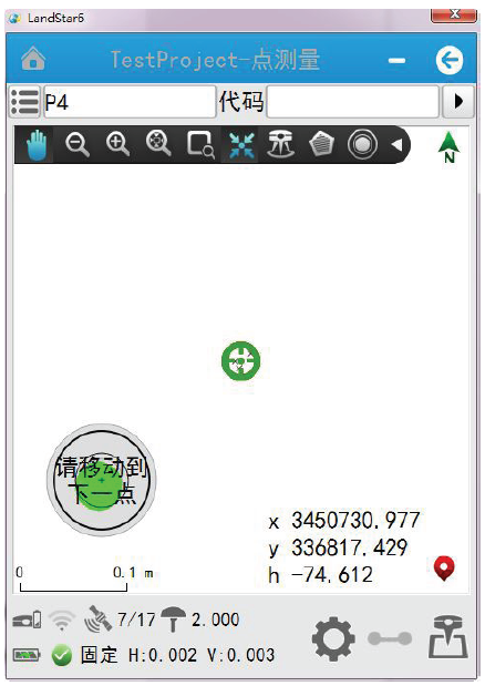
Figure 2: RTK tilt measurement interface
III. RTK Point Correction Precautions
For better accuracy, place known points at the edges of the survey area. If using four points for correction, ensure the measured area lies within the quadrilateral formed by these points. Avoid linearly arranged known points—use regular shapes like triangles or squares for better results. Linear arrangements can severely impact accuracy.
If only horizontal coordinates are needed, at least two points are recommended for correction. For checking horizontal residuals, use three points. If both horizontal and elevation data are required, at least three points are needed, and four for checking both horizontal and vertical residuals.
Ensure the known points are compatible. For example, mixing GPS-derived points with triangulation points might cause large elevation residuals. Always check the horizontal and vertical residuals after correction. If they exceed 2 cm, verify the input data or check for incorrect points. If everything is correct, consider replacing the known point.
Once the point calibration is complete, all measurements from the rover will be in the local plane coordinate system, and you can directly use the results without further adjustments.
4. Resetting Local Coordinates (Important)
To save time during daily operations, you can reset local coordinates each day. Choose a known point from the current survey area (or another known point), measure it, and save the result. In the “File†→ “Element Manager†→ “Point Manager,†find the point you just measured, click “Details,†then “Reset Local Coordinates.†Enter the correct coordinates (not the measured ones), and confirm. Save the task and return to the main interface. This avoids redoing full calibration every day.
Note: The information provided here is based on Chinese test models, and some features may vary depending on the specific RTK system used.
Medical Absorbent Cotton,Sterile Cotton Ball,Sterilized Cotton Balls,Pure Cotton Roll
COTTONWHISPER (TAIZHOU) DAILY PRODUCTS CO.,LTD , https://www.cottonwhipershop.com